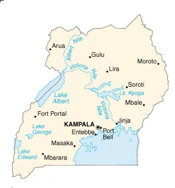
Click on the map above for a larger view.
Uganda is an
extraordinary country. The young Winston Churchill called it the loveliest
area of Africa and one of the most striking in the world. It is quite
beautiful, but it has suffered from enormous deprivation for the last
twenty years.
This has been
due to poor government, political dictatorship and civil war. Now,
however, the country has some measure of political stability and is
beginning to develop again.
But first, let's
find out where Uganda is.
Uganda is situated
on the equator in East Africa and is completely landlocked. Kenya
lies to its east, Zaire is to its west, Somalia to the north and the
huge Lake Victoria to the south. Most of the country is on a single
plateau about 1,200m above sea level... about one hundred metres below
the very top of Ben Nevis.
The capital city
is Kampala. It's a strange city in that many parts of it look more
like what one might have expected a large town in Britain to look
like back in the 1960's, except that where things have broken down
there often hasn't been the money available to get them repaired.
So there are traffic lights that don't work and tilt precariously
across the road where wayward drivers have hit them.
Other parts of
the city are ultra modern with a high rise Sheraton Hotel overlooking
new buildings put up by the World Banks who have realised that the
country is about to become revitalised. There are also many very poor
quality houses, often only single rooms, in which families live. The
power supply is often erratic, and so is the water pressure, and on
a Saturday night, when we would be wary of lager louts in some of
our bigger cities, the citizens of Kampala can often hear the sound
of gunfire from similar hooligans who have found pistols left over
from the civil war. Kampala has a population of about 2.5 million.
It is becoming a very large city.
Uganda has a
population of 23million compared with the population of the United
Kingdom which is about 55 million. It is about the same size as the
United Kingdom, covering an area of a little under 250,000 square
km. A sixth of that land is swamp land and water. The dry land is
split into seven regions for administrative purposes. Each region
is split into a number of districts and these are roughly equivalent
to our counties.
Nine out of ten
people live in the countryside on their own family farms called shambas.
People usually farm 4 to 5 acres in the coffee growing areas of the
country and about double that in the cotton areas. Many men spend
their week days in the cities and towns working there and commute
back to their farms at weekends.
Everyone knows
that many Beaver Scouts find it difficult enough to work out what
is meant by their own town, so it may be very difficult for them to
have anything but the very simplest idea of other countries. However,
there are many things you can do to help them to get an idea of where
Uganda is in the world and how far away it is.
Look at the maps
of Uganda and the United Kingdom. Download
maps of Uganda and the UK.
Help the Beaver
Scouts to locate their town, they may not have met maps before and
it often helps to explain a little about them.
Something like
this might help. 'When we go up in an aeroplane, all the houses, fields
and rivers look smaller and smaller. This is because they become farther
and farther away. If we were to make a plan of what we could see then
that plan would be a map. We use symbols and colours to show what
we can see'.
When you have
found your town, try to show it on a map of the whole of the United
Kingdom. Often children have no idea where their town might be.
(Try it for yourself,
it's an illuminating experience and shows how much we take for granted
in young children!).
Next move to
a globe. Talk about where some of the children have been on holiday.
If they have been abroad, show where they might have been and ask
them how long it took them to travel there. Finally, find Uganda and
trace a route from the United Kingdom to the country of Uganda. Explain
that the journey takes about eight and a half hours by aeroplane.
The Beaver Scouts
might like to use the photocopiable map we have prepared on page 8
to show a route from their home to Kampala! Don't forget, they will
have to travel to an airport first!.
Beaver Scouts
sit in a circle and are given the names of aeroplanes for example:
Concord, Jumbo jet, Hercules etc.
Commands
- When the name
of a plane is called - The Beaver Scouts who have been given that
name jump up and run around the circle.
- 'Engine out'
- Beaver Scouts hop around circle.
- 'Storm approaching'
- Beaver Scouts change direction.
- 'Crash landing'
- Beaver Scouts return to their place in the circle.
The Beaver Scout
Leader then calls the name of another plane. The game continues until
all the planes have 'flown the journey to Uganda'.